


Samani History Route
Samani Coast → Hidaka Yabakei
- 4-hour route
- Geosite map Download PDF file
This route allows visitors to learn about the history of Samani - a town that thrived with the sea. The route incorporates a place of Ainu legends and the site of the Samani Kaisho outpost office, Tojuin Temple, and the Samani Mountain Path.
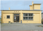
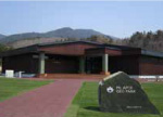
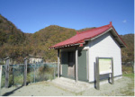
Tourist information center (Former Samani station)
Pick up a pamphlet at the tourist information center in the station building.
Tourist information center
| Open | 8:30 - 16:30 (Weekdays in Nov. - Mar. ;10:00 - 16:00) |
|---|---|
| Closed | Apr. - Oct. ;Open daily Nov. - Mar. ;Wednesday and Thursday Year-end and New Year holidays |
| Tel. | +81-146-36-2551 |

Approx. 5 min. by car
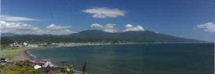
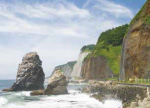
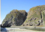
Cape Enrumu C3Geological
Visitors can drive halfway up Cape Enrumu. The site affords sweeping views of Samani, including oddly shaped rocks along the coast, the Apoi Mountains, and Samani Town center. The cape came to be used as a natural harbor, paving the way for Samani to thrive as a trading hub of Ezo (the old name for Hokkaido). (Time required: 10 minutes)
Approx. 1 min. by car
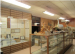
Samani Folk Museum
This small folk museum at the base of Cape Enrumu showcases historical artifacts relating to Samani, which thrived from relatively early on in the young prefecture of Hokkaido. Its old documents from Tojuin Temple (collectively designated as a National Important Cultural Property) are particularly noteworthy. (Time required: 20 minutes)
Samani Folk Museum
| Open | All year round |
|---|---|
| Closed | Mondays and year-end/New Year holidays |
| Hours | 10:00 - 16:30 |
| Admission | Free |
Approx. 3 min. by car
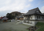
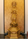
Tojuin Temple C5Historical
This is one of the Three Government Temples of Ezo constructed in 1806 by the Edo Shogunate. Although hardly any of the original structure remains due to several relocations, a valuable statue of Buddha created during the Kamakura period (1185 - 1333) is enshrined in the main hall. (Time required: 20 minutes)
Approx. 1 min. by car
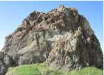
Mt. Kannon C4Geological
Visitors can drive up to the observatory to view a row of oddly shaped rocks and Samani Fishing Port. The name Mt. Kannon derives from the 33 statues of Kannon (known as the Buddhist deity of mercy, or Avalokitesvara-bodhisattva) enshrined in 1895 by Junden Tsukada, the 13th head priest of Tojuin Temple. (Time required: 30 minutes)
Approx. 10 min. by car
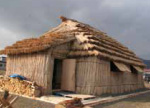
Okada District cise C8Historical
A traditional cise Ainu dwelling has been restored at the previous site of a kotan (Ainu settlement). The various customs observed inside cise included certain seating arrangements and a distinction between religious and secular spaces. (Time required: 10 minutes)
Approx. 15 min. by car
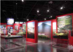
Mt. Apoi Geopark Visitor Center
The visitor center provides information on Mt. Apoi and other aspects of Samani's geology, natural environment, history and culture. (Time required: 30 minutes)
Mt. Apoi Geopark Visitor Center
| Open | April - November |
|---|---|
| Closed | Open daily |
| Hours | 9:00 - 17:00 |
| Admission | Free |
| Tel. | +81-146-36-3601 |
Approx. 5 min. by car
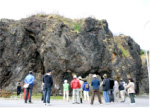
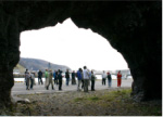
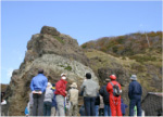
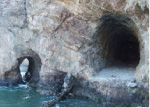
Ana-iwa in Fuyushima D1Geological
Visitors can drive along the national highway to Fuyushima Fishing Port. Ana-iwa (a rock featuring a hole) is called puyo (hole) shuma (stone) in the Ainu language, and the place name Fuyushima derives from the Ainu term. This stone gate appears in the records of various travelers who passed by in the Edo period (1603 - 1868). (Time required: 10 minutes)
Approx. 5 min. by car
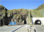
Granite at the Taisho Tunnel D4Geological
Visitors turning right before the Yamanaka Tunnel along the national highway will see an old tunnel. This is known as historically the most difficult place to pass through in the Hidaka Yabakei region. Stroll around the area to see three tunnels from different eras running in parallel. (Time required: 15 minutes)
Approx. 3 min. by car
Geological fold at the Ruranbetsu Tunnel D5Geological
Walk along the Ruranbetsu Tunnel from the Taisho Tunnel area to see folded gneiss and amphibolite by the tunnel. To the east are the precipitous Hidaka Yabakei sea cliffs rising about 100 meters into the air. (Time required: 5 minutes)
Approx. 5 min. by car
Nenbutsu Slope and tunnel at the mouth of the Horoman River
After the Horoman Tunnel on the right, another tunnel from the Meiji period (1868 - 1912) can be seen. During the Edo period (1603 - 1868) before this tunnel was built, people traveling from the west on foot and avoiding the waves are thought to have moved from the rocky shore here and ascended or descended the cliff, which is said to resemble a Japanese folding screen. As they walked, they chanted prayers to the Buddha. (Time required: 5 minutes)
車 約30分
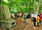
Wasuke Jizo D6Historical
After the Horoman Bridge is a small shrine on the left. Inside is a statue of Jizo - the guardian deity of travelers and children. It is dedicated to Wasuke Saito, who contributed to the construction of the Samani Mountain Path in the Edo period (1603 - 1868). The completion of this path and the establishment of the Samani Kaisho outpost office and Tojuin Temple around 200 years ago laid the foundations for Samani as it is today. (Time required: 10 minutes)

Approx. 20 min. by car