


Petit Geo Route
Samani Coast → Hidaka Yabakei → Horomankyo Gorge
- 4-hour route
- Geosite map Download PDF file
This route is ideal for enjoying Samani's scenery with a geological flavor. The sights include Cape Enrumu, Oyako-iwa and other oddly shaped rocks along the coast, Hidaka Yabakei sea cliffs, and the Horomankyo Gorge with its rich natural environment.
Tourist information center (Former Samani station)
Pick up a pamphlet at the tourist information center in the station building.
Tourist information center
| Open | 8:30 - 16:30 (Weekdays in Nov. - Mar. : 10:00 - 16:00) |
|---|---|
| Closed | Apr. - Oct. : Open daily Nov. - Mar. : Wednesday and Thursday Year-end and New Year holidays |
| Tel. | +81-146-36-2551 |

Approx. 5 min. by car
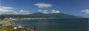
Cape Enrumu C3Geological
Visitors can drive halfway up Cape Enrumu. The site affords sweeping views of Samani, including oddly shaped rocks along the coast, the Apoi Mountains and Samani Town center. Checking out the view from the observation platform up the stairs is also recommended if time permits. (Time required: 10 minutes)
Approx. 3 min. by car
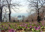
Mt. Kannon C4Geological
Visitors can drive up to the observatory to view a row of oddly shaped rocks and Samani Fishing Port. From early spring onward, flowers continue to bloom in the area. These include Ezoengosaku (Corydalis ambigua), dogtooth violets (Erythronium japonicum) and Oobananoenreiso (Trillium camschatcense). (Time required: 20 minutes)
Approx. 5 min. by car
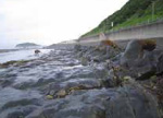
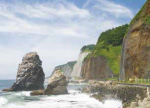
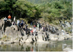
Byobu Cliff in Hirau C6Geological
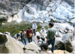
Layers of conglomerate and sandstone deposited on shallow sea beds are found in the area from the towering cliff, which is said to resemble a Japanese folding screen, to the sandy beach below the national highway. Visitors going down to the sandy beach at low tide will find a bounty of shell fossils in the sandstone. (Time required: 15 minutes)
Approx. 5 min. by car
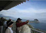
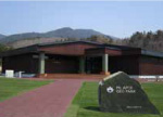
Mt. Apoi Geopark Visitor Center
The visitor center provides information on Mt. Apoi and other aspects of Samani's geology, natural environment, history and culture. (Time required: 30 minutes)
Mt. Apoi Geopark Visitor Center
| Open | April - November |
|---|---|
| Closed | Open daily |
| Hours | 9:00 - 17:00 |
| Admission | Free |
| Tel. | +81-146-36-3601 |

Approx. 5 min. by car
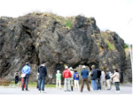
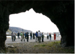
Ana-iwa in Fuyushima D1Geological
Visitors can drive along the national highway to Fuyushima Fishing Port. Although the rock here is metamorphic hornfels, close inspection shows a schistose structure typical of sedimentary rock. The Hidaka Yabakei sea cliffs extend from here. (Time required: 10 minutes)
Approx. 5 min. by car
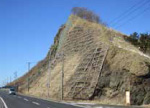
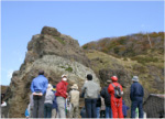
Granite at the Taisho Tunnel D4Geological
Visitors turning right before the Yamanaka Tunnel along the national highway will see an old tunnel. Granite can be seen intruding into gneiss along the coast here. Stroll around the area to see three tunnels from different eras running in parallel. (Time required: 15 minutes)
Approx. 3 min.on foot
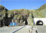
Geological fold at the Ruranbetsu Tunnel D5Geological
Walk along the Ruranbetsu Tunnel from the Taisho Tunnel area to see folded gneiss and amphibolite by the former. To the east are the precipitous Hidaka Yabakei cliffs and Unotori-iwa rock in the sea. (Time required: 5 minutes)
Approx. 20 min. by car
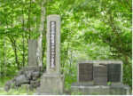
Japanese White Pine Monument A3Geological
The area's Japanese white pines have been collectively designated as a Natural Monument of Japan. Go down the trail from the monument to the riverbank to see a beautiful peridotite gorge. Japanese pikas are known to inhabit the surrounding area. (Time required: 15 minutes)
Approx. 10 min. by car
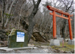
Horoman-gawa Inari Shrine A6Geological
This shrine was built in 1936 in conjunction with the construction of the Horoman River Hydroelectric Power Plant, which paved the way for the development of electric power resources in the Hidaka region. At the riverbank 100 meters upstream from the shrine, white peridotite surfaces exposed by whitewater rapids create a characteristic landscape. (Time required: 15 minutes)
Approx. 10 min. by car
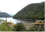
Horoman Dam A7Geological
A spectacular vista opens up out of the blue in the dam area, which represents the northern edge of the Horoman peridotite complex. Due to the 1954 construction of the Horoman Dam for Power Station No. 3, the community living in the area relocated. The site of the community's settlement previously located in the upstream area now sits at the bottom of the lake created by the dam. (Time required: 5 minutes)
Approx. 40 min. by car